Vancouver, British Columbia, Canada, July 18, 2018, Klondike Gold Corp. (TSX.V: KG; FRA: LBDP; OTC: KDKGF) (“Klondike Gold” or the “Company”) is pleased to report assays from seven drill holes at the Lone Star Zone, part of a systematic evaluation designed to map the geometry of mineralization across a portion of the Zone, at the Company’s wholly owned Klondike District Property, Yukon Territory. Results of the first seven holes, LS18-151 to LS18-157, testing the Lone Star Zone in 2018, are reported here.
A minimum total of $2.5M has been budgeted for 2018 exploration (March 9, 2018 news release). The Company in 2018 has exploration plans underway to drill test the Lone Star Zone, the Nugget Fault Zone, and the Gold Run target plus complete comprehensive district-wide mapping, geophysics, and soil surveys for the first time. The Company is fully funded through 2019 at a similar level of expenditure.
SUMMARY:
- Hole LS18-156 assays 1.40 g/t Au over 65.05 meters from surface at 2.50 to 67.55 meters downhole, including 6.07 g/t Au over 8.45 meters from 6.65 to 15.10 meters.
- Exploration program results from ongoing Lone Star drilling, Gold Run drilling, Nugget and Gay Gulch re-evaluation assaying, and district-scale exploration are pending.
PREAMBLE:
The Company in 2014 interpreted a series of previously unrecognized district-scale faults (Bonanza, Nugget, Eldorado, and Irish Faults, and the Rabbit Creek Thrust) from magnetic surveys. During 2015 and 2016 the Company focussed exploration on gold-bearing quartz veins as had previous explorers over the past 120 years. Target areas of higher grades over narrower intervals identified during these programs are evident at Gay Gulch (76.0 g/t Au over 2.8 meters) and Nugget Zone (5.1 g/t Au over 14.3 meters) and remain targets of future exploration. Currently the Company is preferentially targeting and outlining broad zones of lower grade mineralization at or near surface that characteristically contain visible, relatively coarse free gold.
Late in 2016 the Company recognized the potential for gold disseminated in the host rock adjacent to quartz veining at the Lone Star Zone (see NR 1 November 2016). The follow-up 2017 drill program intersected near-surface gold at 50 meter intervals across 1,000 meters of strike length (see NR 10 January 2018), and with broad exploration step-outs intersected gold over 2,700 meters.
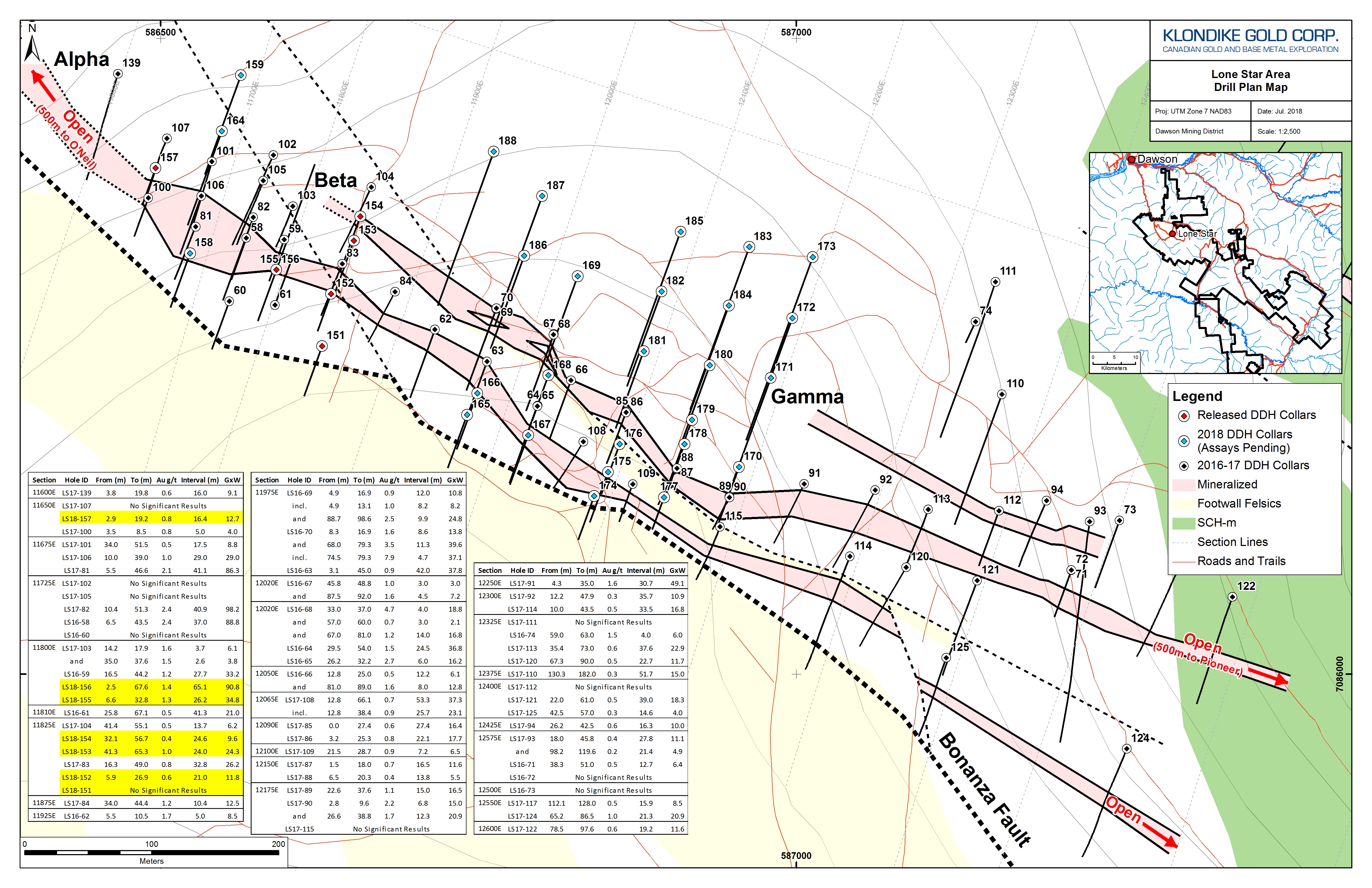
The Company in 2018 is undertaking systematic evaluation of the Lone Star Zone designed to map geometry and tenor of mineralization across a 550 meter portion to a down-dip extent of 100 to 250 meters by completing a series of 12 fences of holes. Approximately 40 holes in 2018 are planned, and coupled with 2016 and 2017 holes, are expected to create 12 detailed drill sections with geology and assay data. Results of the first seven holes, LS18-151 to LS18-157, testing the Lone Star Zone in 2018, are reported here.
DISCUSSION
Lone Star Zone gold mineralization is interpreted to have a 2,400 meter strike length from 11100E at O’Neil Gulch (hole LS17-97; see NR 18 September 2017) to outcrops on 13500E in Victoria Gulch (see NR 16 August 2017). The Company in 2017 focussed on the 1,000 meter length from line 11600E (hole LS17-139) to line 12600E (LS17-104) by drill testing every 50 meters along strike and intersecting gold mineralization in each hole in this distance (see NR 10 January 2018). The ongoing 2018 drill program is systematically grid testing 550 meters along strike by 250 meters down dip on 50 meter spacing from line 11650E to 11200E, for an approximate total of 40 drill holes.
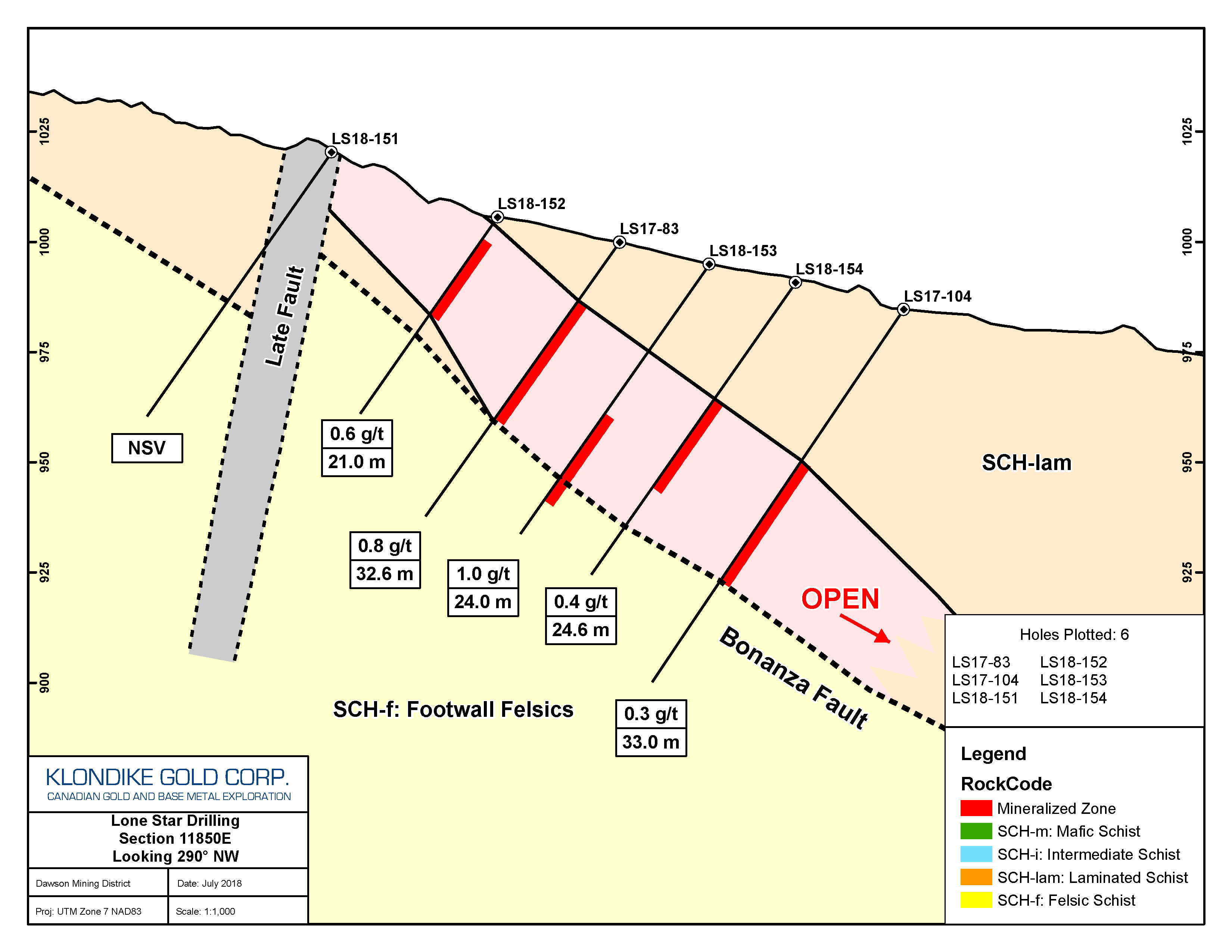
Holes LS18-151 to -157 reported here were drilled to infill or extend three fences of drill holes on 11650E, 11800E, and 11850E. Plan maps plus full sections including previous results are posted on the company’s website here: https://www.klondikegoldcorp.com/photos/gallery/2018-drill-maps
The significant highlight from these results is the test by LS18-155 / LS18-156. These were drilled from the same collar, with LS18-156 turned in the opposite direction. The objective was to test the grade and extent of near-surface gold mineralization. LS18-155 intersected 1.33 g/t Au over 26.20 meters drilled southerly; LS18-156 intersected 1.4 g/t Au over 65.05 meters drilled northerly from the same origin. These intersections start at surface and are entirely within 45 meters of surface. Also, the sub-interval in LS18-156 of 6.07 g/t Au over 8.45 meters suggests there are higher grade pockets of mineralization.
All other holes within the mapped mineralized envelope intersected broad zones of gold mineralization as expected. The section including holes LS18-151 to -154 indicates down-dip continuity of mineralization at shallow depths as the mineralization dips sub-parallel to the topography. Part of the current program is to locate the up-dip termination of mineralization. LS18-151 drilled above the termination and did not intersect any mineralization.
Results from six drill holes LS18-152 to -157 all indicate broad intersections of near-surface gold mineralization, listed in the accompanying table.
TABLE OF LONE STAR ZONE DRILL HOLE WEIGHTED AVERAGE ASSAY INTERVALS:
| Hole ID | From (m) | To (m) | Au g/t | Interval (m) |
| LS18-151 | No significant value: felsic footwall | |||
| LS18-152 | 5.90 | 26.90 | 0.56 | 21.00 |
| LS18-153 | 41.30 | 65.30 | 1.01 | 24.00 |
| LS18-154 | 32.10 | 56.65 | 0.39 | 24.55 |
| LS18-155 | 6.60 | 32.80 | 1.33 | 26.20 |
| LS18-156 | 2.50 | 67.55 | 1.40 | 65.05 |
| Including | 6.65 | 15.10 | 6.07 | 8.45 |
| And | 26.10 | 37.50 | 1.91 | 11.40 |
| And | 47.25 | 53.90 | 1.48 | 6.65 |
| LS18-157 | 2.85 | 19.20 | 0.78 | 16.35 |
A plan map of Lone Star Zone planned/drilled hole locations, plus cross sections for 2018 holes including 2016-2017 holes, are included below and are available on the Company’s website https://www.klondikegoldcorp.com/photos/gallery/2018-drill-maps
Drill holes LS18-151 to -155, and LS18-157 were drilled at -55 dip and 200 azimuth. LS18-156 was drilled at -55 dip and 020 azimuth from the same location as LS18-155. Assay averages are calculated over drilled core lengths; true thickness from holes drilled at 200 azimuth is approximately the drilled interval, as shown in the accompanying section maps.
Lone Star Zone Drill Update:
The ongoing drill program is systematically testing sections across the Lone Star Zone to outline the geometry, continuity, and extent of disseminated gold mineralization and gold-bearing quartz vein mineralization. Approximately 38 drill holes testing the Lone Star Zone will soon be completed. Further results from these holes are expected in batches ranging in time from August through mid-September.
Gold Run Target Drill Update:
Four NQ diamond drill holes GR18-160 to -163 tested the Gold Run target area. Assay results are expected in August.
Nugget Zone and Gay Gulch Re-evaluation Update:
Examination and additional sampling of 2015 and 2016 drill holes along the Nugget Fault trend and at Gay Gulch continues. Assay results are expected in batches ranging in time from August through September.
Klondike District Exploration Update:
Systematic district-scale exploration for the first time across the Company’s property is progressing. This program includes soils, airborne magnetics, radiometric, and VLF-EM surveying, plus detailed structural and lithologic mapping and prospecting. Results are expected in August and September.
QUALITY ASSURANCE AND METHODS
Klondike Gold maintains a rigorous quality assurance / quality control (“QA/QC”) program. Details can be viewed on the Company’s website https://www.klondikegoldcorp.com/projects/sampling-and-assay-protocols/.
Drill core samples are submitted by Klondike Gold personnel to Bureau Veritas Mineral Laboratories (“BV Labs”) (formerly Acme Labs) preparation facility in Whitehorse, YT with chemical analysis of sample pulps completed in Vancouver, British Columbia. Bureau Veritas Labs is an accredited ISO 9001:2008 full-service commercial laboratory. All drill core samples are assayed for gold by fire assay (“FA”) fusion with a gravimetric finish. Full sampling/assay procedures and protocols can be viewed on the Company’s website https://www.klondikegoldcorp.com/projects/sampling-and-assay-protocols/.
The technical and scientific information contained within this news release has been reviewed and approved by Ian Perry, P.Geol., Vice-President Exploration of Klondike Gold Corp. and Qualified Person as defined by National Instrument 43-101 policy.
ABOUT KLONDIKE GOLD CORP.
Klondike Gold Corp. is a Canadian exploration company with offices in Vancouver, British Columbia, and Dawson City, Yukon Territory. The Company is focused on exploration and development of the Lone Star gold target at the confluence of Bonanza and Eldorado Creeks, within a district scale 557 square kilometer property accessible by government maintained roads located on the outskirts of Dawson City, YT within the Tr’ondëk Hwëch’in First Nation traditional territory.
On behalf of KLONDIKE GOLD CORP.
“Peter Tallman”
President and CEO
(604) 609-6110
E-mail: info@klondikegoldcorp.com
Website: www.klondikegoldcorp.com
Neither the TSX Venture Exchange nor its Regulation Services Provider (as that term is defined in the policies of the TSX Venture Exchange) accepts responsibility for the adequacy or accuracy of this release.
Disclaimer for Forward-Looking Information
“This press release contains “forward-looking information” and “forward-looking statements” within the meaning of applicable securities laws. This information and statements address future activities, events, plans, developments and projections. All statements, other than statements of historical fact, constitute forward-looking statements or forward-looking information. Such forward-looking information and statements are frequently identified by words such as “may,” “will,” “should,” “anticipate,” “plan,” “expect,” “believe,” “estimate,” “intend” and similar terminology, and reflect assumptions, estimates, opinions and analysis made by management of Klondike in light of its experience, current conditions, expectations of future developments and other factors which it believes to be reasonable and relevant. Forward-looking information and statements involve known and unknown risks and uncertainties that may cause Klondike’s actual results, performance and achievements to differ materially from those expressed or implied by the forward-looking information and statements and accordingly, undue reliance should not be placed thereon.
Risks and uncertainties that may cause actual results to vary include but are not limited to the availability of financing; fluctuations in commodity prices; changes to and compliance with applicable laws and regulations, including environmental laws and obtaining requisite permits; political, economic and other risks; as well as other risks and uncertainties which are more fully described in our annual and quarterly Management’s Discussion and Analysis and in other filings made by us with Canadian securities regulatory authorities and available at www.sedar.com. Klondike disclaims any obligation to update or revise any forward-looking information or statements except as may be required.”