Vancouver, British Columbia, Canada, August 6, 2019, Klondike Gold Corp. (TSX.V: KG; FRA: LBDP; OTC: KDKGF) (“Klondike Gold” or the “Company”) is pleased to report assays from nine drill holes testing the Nugget Zone along the Nugget Fault on the Company’s wholly owned 576 square kilometer Klondike District Property, Yukon Territory.
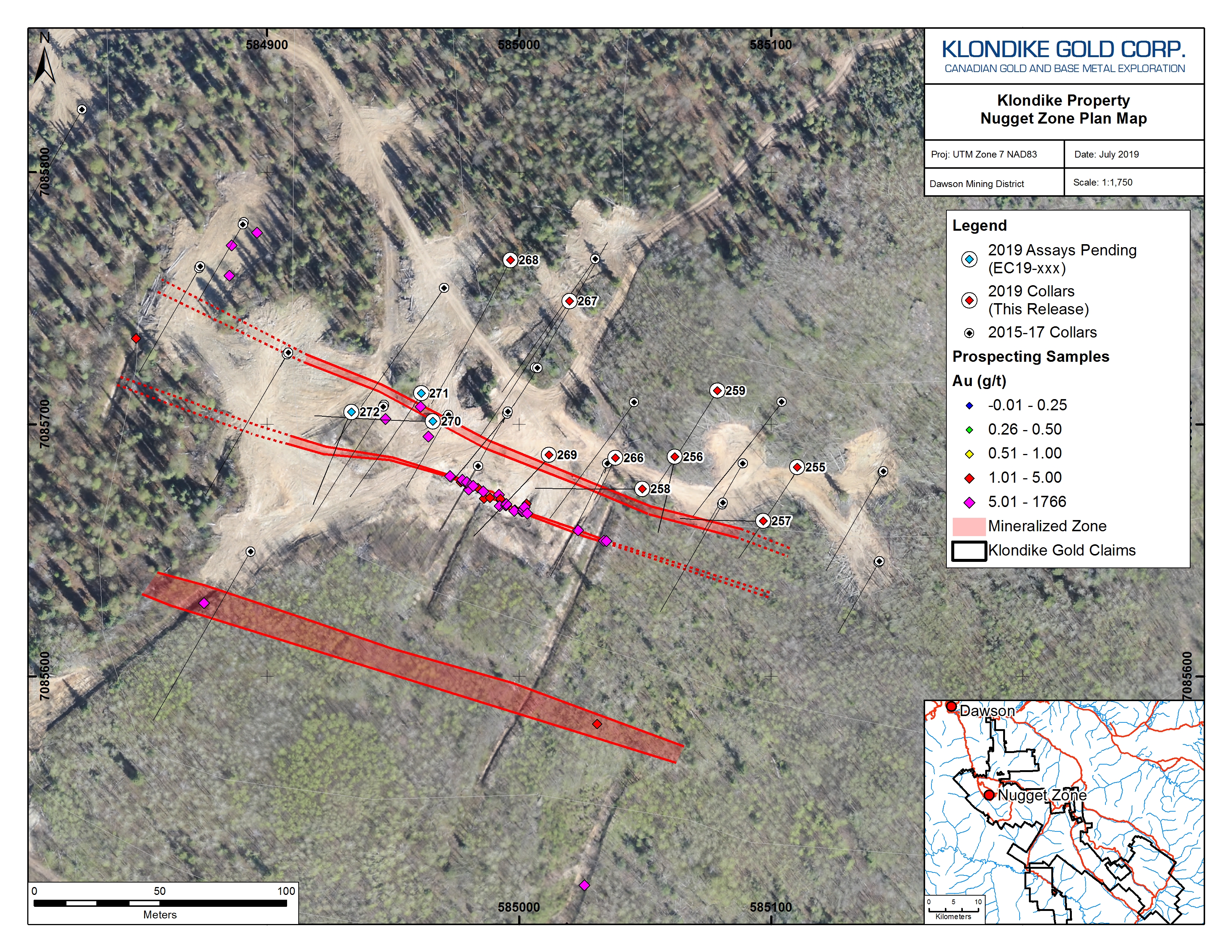
Assay results for samples from nine (9) drill holes (EC19-255 to EC19-259 plus EC19-266 to EC19-269) have been received, with assay results for three (3) drill holes (EC19-270 to EC19-272) still pending. A total of twelve (12) drill holes totalling 913 metres tested the Nugget Zone.
Highlights:
The Nugget Zone is associated with a prominent, eight-kilometer long magnetic low named the Nugget Fault which hosts gold-bearing quartz veins at Glacier Gulch, Nugget East, Upper Eldorado, several newly discovered c.1900 small mine workings, and outcrops located over a 2.5 kilometer strike length. Drilling targeting the Nugget Fault including the Nugget Zone began around mid-June (see News Release June 10, 2019).
The objectives of drilling the Nugget Zone were to target prospective areas of high-grade gold mineralization and to improve structural understanding by capturing structural measurement data on rock fabrics and gold-bearing quartz vein orientations. Larger diameter HTW-size drill core was used to improve core recovery and to increase analytical precision by increasing core sample size.
Results from drill holes EC19-255 to EC19-259, and EC19-266 to EC19-269 are listed in the following table:
| Hole ID | From (m) | To (m) | Au (g/t) | Ag (g/t) | Length (m) |
| EC19-255 | 58.0 | 60.0 | 0.5 | 0.4 | 2.0 |
| EC19-256 | 5.9 | 27.4 | 4.3 | 1.1 | 21.5 |
| including | 17.4 | 27.4 | 8.9 | 1.9 | 10.0 |
| including | 19.9 | 20.4 | 19.7 | 1.4 | 0.5 |
| including | 22.9 | 23.4 | 20.2 | 3.6 | 0.5 |
| including | 25.8 | 26.3 | 113.6 | 17.2 | 0.5 |
| EC19-257 | 4.0 | 51.2 | 0.6 | 0.5 | 47.2 |
| including | 13.4 | 21.8 | 2.5 | 1.1 | 8.4 |
| including | 17.8 | 18.3 | 26.1 | 7.0 | 0.5 |
| EC19-258 | 21.7 | 52.2 | 0.4 | 0.5 | 30.5 |
| including | 21.7 | 24.7 | 1.8 | 0.8 | 3.0 |
| EC19-259* | 67.4 | 80.8 | 1.4 | 2.4 | 13.4 |
| including | 74.4 | 74.8 | 1.7 | 9.8 | 0.4 |
| EC19-266 | 4.6 | 54.2 | 1.8 | 0.8 | 49.6 |
| including | 4.6 | 19.7 | 3.9 | 1.3 | 15.1 |
| including | 9.5 | 10.1 | 78.8 | 13.9 | 0.6 |
| and | 36.7 | 54.2 | 1.6 | 0.8 | 17.6 |
| including | 37.4 | 38.4 | 22.2 | 1.7 | 1.0 |
| EC19-267 | 70.9 | 79.6 | 0.4 | 2.2 | 8.7 |
| including | 70.9 | 71.8 | 1.1 | 11.3 | 0.9 |
| and | 94.2 | 95.2 | 1.2 | 1.5 | 1.0 |
| and | 104.0 | 106.5 | 404.2 | 415.4 | 2.5 |
| including | 104.0 | 105.0 | 1,009.5 | 1,035.5 | 1.0 |
| EC19-268 | 40.0 | 40.5 | 1.1 | 21.7 | 0.5 |
| EC19-269 | 10.0 | 28.2 | 0.7 | 0.7 | 18.2 |
NOTES:
The true thickness of reported drill intervals cannot be determined with the information currently available.
*Hole EC19-259 ended in mineralization.
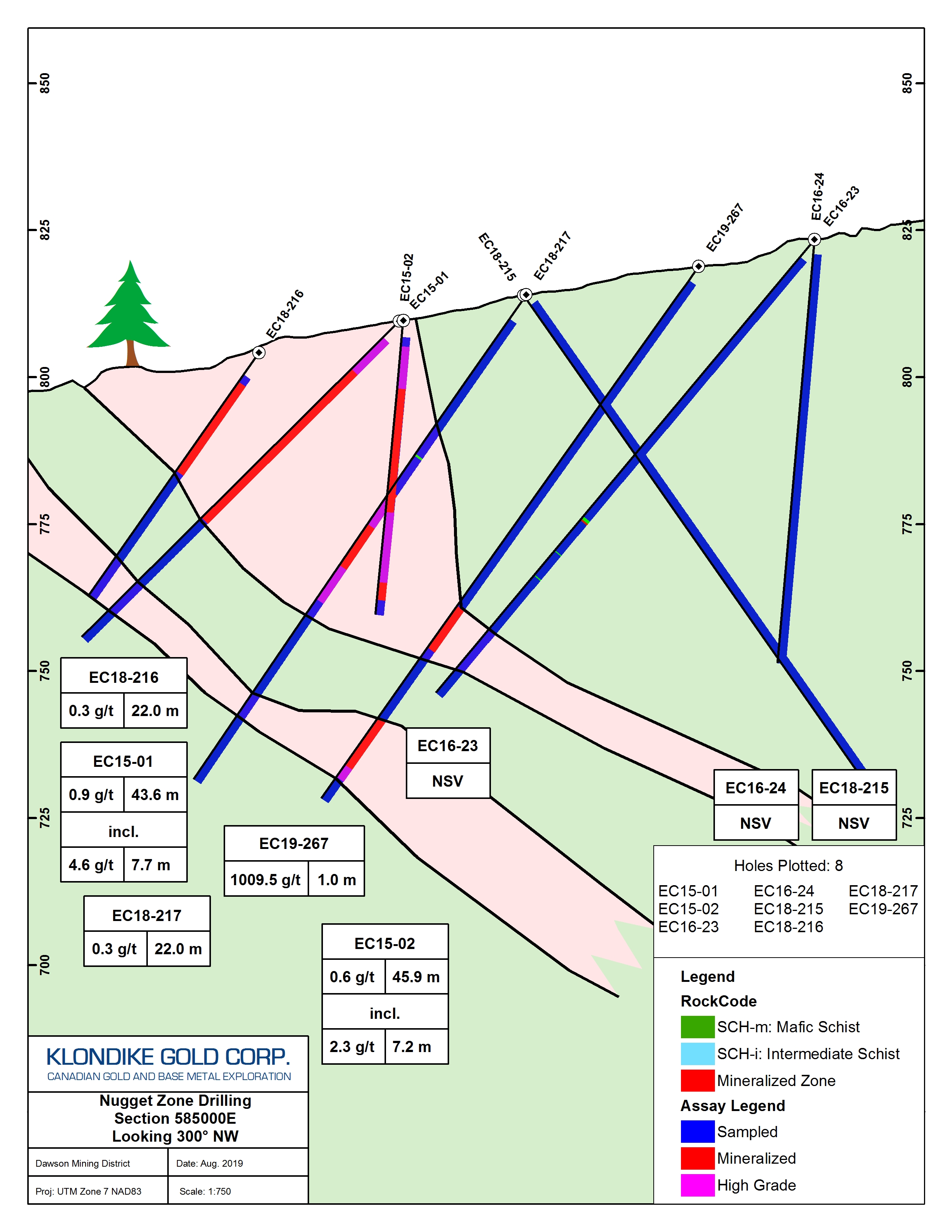
EC19-267 from 104.0 to 105.0 meters downhole intersected an averaged grade of 1,009 g/t gold and 1,035 g/t silver over a 1.0 meter interval. This one-meter interval is a mafic schist containing coarse 2 cm size cubic pyrite in a chocolate coloured presumed ankerite alteration zone that includes a 0.4 meter rubble interval with pyrite. From 105.0 to 106.5 meters downhole the coarse pyrite content decreases and typically gold-bearing cross-cutting quartz veins occur.
Hole EC19-267 was drilled at 200 azimuth, -55 inclination, to a downhole depth of 111.25 meters. The 104.0 to 105.0 meters downhole interval is 75 meters vertically from surface.
Nugget Zone high grade gold-silver mineralization in EC19-267 is comparable to other occurrences sampled in 2014 to 2018 within the Klondike District Property. In 2014, sampling of a sulphidized outcrop yielded up to 1,766 g/t Au with 400 g/t Ag from prospecting rock samples (see News Release January 14, 2015). In 2017, quartz veins were grab sampled that contained 24 and 96 g/t gold, with 110 and 149 g/t silver (see News Release September 28, 2017; O’Neill area quartz veins with Au and Ag). (Prospecting grab samples are selective in nature; systematic test results may vary significantly). The gold-silver association may be used as an exploration tool to target the highest gold grades, using the Company’s evolving structural knowledge from mapping and oriented core measurements.
Drill cross-section and a location maps are included hereto as:
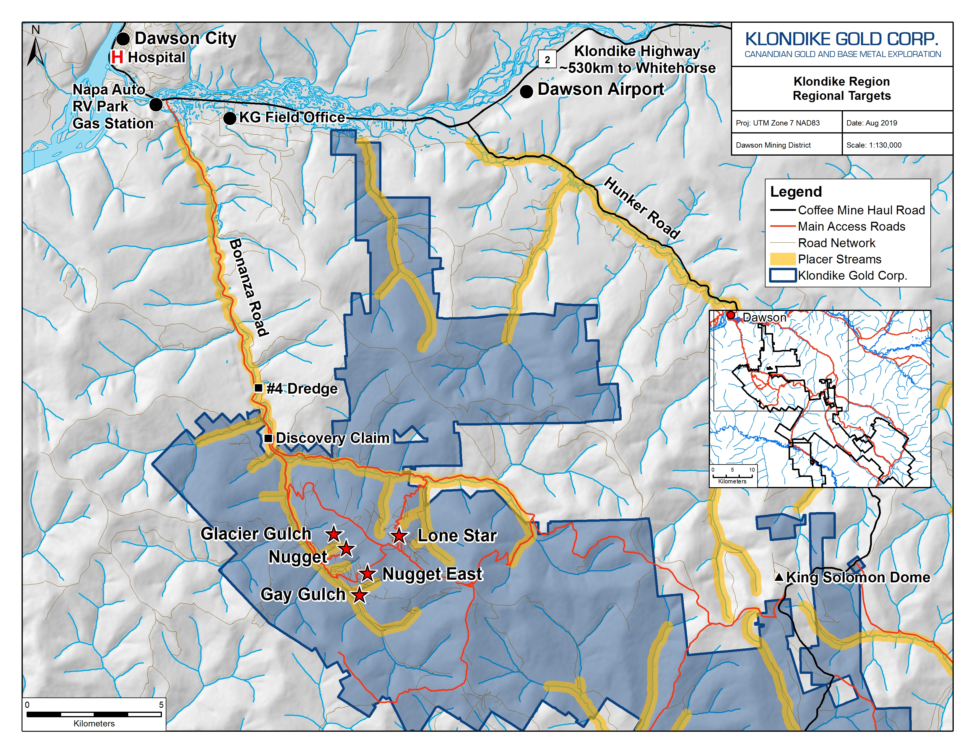
Figure 1: Location of 2019 Drill Target Zones and nearby prospects, Klondike District Property
Figure 2: Nugget Zone 2019 Drill Plan Map
Figure 3: Nugget Zone Hole EC19-267 Cross Section Map
Sample and Analytical Protocols
Sample 1832529, the 1.0 meter interval in EC19-267 from 104.0 to 105.0 meters, was re-assayed as 1832529 DUPLICATE. Gold and silver concentrations obtained were within analytical limits. For this news release, the gold and silver results from 1832529 and 1832529 DUPLICATE were mathematically averaged to create the “Average” concentrations. The analytical results are listed in the following table:
| Sample ID | Type | Master Sample Weight (g) | Sample Split Weight (g) | Au (g/t) | Ag (g/t) |
| 1832529 | DRILL CORE | 3,820 | 404 | 982.46 | 943 |
| 1832529 | DUPLICATE | 400 | 1036.47 | 1128 | |
| 1832529 | Average | 1009.5 | 1035.5 |
All Nugget Zone samples in this release are from “HTW” size drill core. Assay samples from drill core are cut using a diamond saw. Half the core sample interval is bagged, tagged, and sealed; the other half is returned to the core box with a corresponding tag and retained for reference. Three gold reference standards, blanks, coarse crush blanks, and sample duplicates are routinely inserted as part of Klondike Gold’s quality assurance / quality control (“QA/QC”) program, independent of and additional to the laboratory QA/QC program.
Sample bags are aggregated into rice bags, sealed, and submitted by Klondike Gold personnel to Bureau Veritas Mineral Laboratories (“BV Labs”) (formerly Acme Labs) preparation facility in Whitehorse, YT with chemical analysis of sample pulps completed in Vancouver, British Columbia. Bureau Veritas Labs is an accredited ISO 9001:2008 full-service commercial laboratory.
At BV Labs each drill core sample is crushed to 70% passing 2 mm size. A 400 g subsample is pulverized to 85% passing 75 microns size (200 mesh)(Code PRP70-500). (In addition, from the 1832529 master, a second ~400 g subsample “1832529 DUPLICATE” was prepared by the same method). All samples of 400 g were sieved to 106 microns (140 mesh) for “metallic screen” assaying. The +140 mesh fraction is weighed and assayed for gold by fire assay (“FA”) fusion with a gravimetric finish (Code FS631). A 30 g subsample of the -140 mesh fraction is assayed for gold by fire assay (“FA”) fusion with an atomic absorption (“AA”) finish (Code FA430). All over-limit results in excess of 10 ppm (10 g/t) for both silver and gold are re-assayed using a 30 g subsample and assayed by FA with a gravimetric finish (Code FA530-Au/Ag). Total gold grade is then calculated using a weighted average of the plus and minus fraction assay results.
Drill Hole Statistics
Drill holes at the Nugget Zone are generally oriented with 210 azimuth and -55 dip at collar. During this program, several holes had -50 or -80 dips at collar, and several were oriented with 270 azimuth. The purpose of varying collar dip and azimuth was to obtain structural measurements from the use of oriented core tools.
Location, azimuth, dip and end of hole (“EOH”) lengths for drill holes in this news release are listed in the following table:
| Hole Number | Easting | Northing | Azimuth | Dip | EOH |
| EC19-255 | 585115 | 7085683 | 210 | -55 | 76.20 |
| EC19-256 | 585061 | 7085686 | 210 | -55 | 54.86 |
| EC19-257 | 585098 | 7085662 | 270 | -50 | 51.82 |
| EC19-258 | 585050 | 7085676 | 270 | -50 | 65.53 |
| EC19-259 | 585076 | 7085713 | 210 | -55 | 80.77 |
| EC19-266 | 585037 | 7085689 | 210 | -80 | 71.63 |
| EC19-267 | 585017 | 7085736 | 210 | -55 | 111.25 |
| EC19-268 | 585003 | 7085756 | 210 | -55 | 112.78 |
| EC19-269 | 585019 | 7085702 | 210 | -55 | 76.20 |
QUALIFIED PERSONS REVIEW
The technical and scientific information contained within this news release has been reviewed and approved by Ian Perry, P.Geo., Vice-President Exploration of Klondike Gold Corp. and Qualified Person as defined by National Instrument 43-101 policy.
ABOUT KLONDIKE GOLD CORP.
Klondike Gold Corp. is a Canadian exploration company with offices in Vancouver, British Columbia, and Dawson City, Yukon Territory. The Company is focused on exploration and development of the Lone Star gold target at the confluence of Bonanza and Eldorado Creeks, within a district scale 576 square kilometer property accessible by government maintained roads located on the outskirts of Dawson City, YT within the Tr’ondëk Hwëch’in First Nation traditional territory.
On behalf of KLONDIKE GOLD CORP.
“Peter Tallman”
President and CEO
(604) 609-6110
E-mail: info@klondikegoldcorp.com
Website: www.klondikegoldcorp.com
Neither the TSX Venture Exchange nor its Regulation Services Provider (as that term is defined in the policies of the TSX Venture Exchange) accepts responsibility for the adequacy or accuracy of this release.
Disclaimer for Forward-Looking Information
“This press release contains “forward-looking information” and “forward-looking statements” within the meaning of applicable securities laws. This information and statements address future activities, events, plans, developments and projections. All statements, other than statements of historical fact, constitute forward-looking statements or forward-looking information. Such forward-looking information and statements are frequently identified by words such as “may,” “will,” “should,” “anticipate,” “plan,” “expect,” “believe,” “estimate,” “intend” and similar terminology, and reflect assumptions, estimates, opinions and analysis made by management of Klondike in light of its experience, current conditions, expectations of future developments and other factors which it believes to be reasonable and relevant. Forward-looking information and statements involve known and unknown risks and uncertainties that may cause Klondike’s actual results, performance and achievements to differ materially from those expressed or implied by the forward-looking information and statements and accordingly, undue reliance should not be placed thereon.
Risks and uncertainties that may cause actual results to vary include but are not limited to the availability of financing; fluctuations in commodity prices; changes to and compliance with applicable laws and regulations, including environmental laws and obtaining requisite permits; political, economic and other risks; as well as other risks and uncertainties which are more fully described in our annual and quarterly Management’s Discussion and Analysis and in other filings made by us with Canadian securities regulatory authorities and available at www.sedar.com. Klondike disclaims any obligation to update or revise any forward-looking information or statements except as may be required.”